Matagorda Island separates Espiritu Santo Bay and San Antonio Bay from the Gulf of Mexico. On its southwestern end it is separated by a channel from St. Joseph’s Island and at the northeastern end, Pass Cavallo separates it from Matagorda Peninsula. This sandy barrier island is about 2 miles wide and approximately 50 miles long. The Matagorda State Parks and Wildlife Area is located at the eastern portion of the island.
As a wildlife refuge, it is extremely important to the survival of many species. Salt and cord grasses and tidal flats and marshes make up much of the island. Many species of fish owe their existence to these nurseries. Matagorda is the home of 20 protected species. White-tailed deer, coyote, jackrabbit, and feral hogs as well as the rattlesnake are common on the island. It is the home of 300 species of birds as well as the newly reintroduced Aplomado Falcon.
The island was a stopping place for the Karankawa Indians, local to this area. It was probably not seen by Europeans until 1519 when Alonso Alvarez de Pineda sailed the Gulf coast and created the first map of the area. When La Salle made landfall in Texas he set up a prime campsite on Matagorda. The first real settlement was the town of Calhoun and was laid out on the northwest section of the island in 1839. Although it had its own customs house, the town did not survive and Galveston Island became the new home for the customs house in 1844.
On March 17, 1847, James Power, an original Empresario, working with Alexander Somervell and Milford Norton, created the plan for the town of Saluria. On March 17, 1847, Power deeded the site of the town to Somervell, Denison and Rose. Three hundred lots were laid out for the future town site. Wharves and piers were built and lighters, flat-bottomed boats designed to carry heavy loads, were used to ship goods to ports in Matagorda Bay.
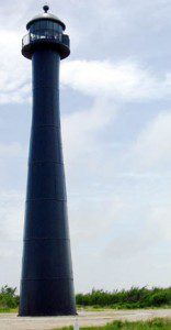
Due to problems docking ships, the customhouse was moved to La Salle and took much of the shipping with it. The Post office was established in 1848. Governors Henry Smith and Edmund J. Davis are said to have had homes there. Near Saluria, the government built a lighthouse to protect ships entering the somewhat treacherous Pass Cavallo.
When the Civil War broke out, Camp Washington, established during the Texas Revolution by General Albert Sidney Johnston, was already located on the northeastern tip of Matagorda. At the start of the war, two companies of the 4th Texas Artillery were sent to that post. Commander Major Daniel Shea moved Fort Washington two miles up Pass Cavallo to a rise of ground. This new location became known as Ft. Esperanza. It was first garrisoned in December 1861. In November, 500 confederate troops abandoned the fort after a four day siege. In June of 1864 Federal troops, who had taken over the fort, withdrew for the last time.
After the war residents moved back to the island and attempted to recover the status they had lost during the conflict. Unfortunately, in 1875, the hurricane that did so much damage to Indianola also destroyed Saluria. Although they attempted to recover, the storm of 1886 was the final death knell for the once thriving port.
During World War II, the federal government used Matagorda Island as a bombing range. Craters are still visible today from these practice runs. Through the years, the Island claimed a life saving station that eventually became a Coast Guard Station. Matagorda was essential to the control of Texas and the Gulf during the Civil War and World War II. Now, when visitors go to the island, they can still see evidence of these trying periods in Texas’s history. They are also treated to a beautiful Gulf beach, birds and other wildlife as well as the essence of the past.

